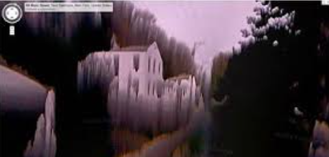
To the image to your right, you are most likely seeing a strange, distorted, creepy town. It was originally a street view panorama from Google Maps, but became better known from a 4 minute 27 second long clip by LittleSkullKid on Youtube.com and left people with a feeling of disturbance and curiosity. Where is this place, but more commonly, what is this place?
The clip shows the town, New Baltimore located in Greene County, New York. New Baltimore is a peaceful, rural town in Eastern New York. Its landmass is 60.44 sq miles and the population is 11,280 in 2023. The town was formerly owned by a tribe of Indians called the Mahican, but the land was colonized by the Dutch and English during the early 1700s and became a town on March 15, 1811 by an act of the New York State Legislature. The town was mainly used as an area for farmland and by 1875, 248 farms (33,882 acres) were present. If you search this place up on the web you will probably see a completely normal town. But why does it look so different in the image?
People wondered and created theories about this image, but the mystery is still unsolved. The most common and realistic theory was the cause of a bug in the software or the failure of the equipment. Ever since the panorama was first published in 2007, people became curious and numerous speculations filled the internet.
Citations: